五度妙笔
五度妙笔 企业透视镜
企业透视镜 API商城
API商城
 数据库
数据库《海洋预报》| 山东半岛连续两次冰雹天气风廓线雷达特征分析

山东半岛连续两次冰雹天气风廓线雷达特征分析
全文请用PC端下载 地址:
http://www.hyyb.org.cn/Magazine/Show.aspx?ID=3693
读书小笔记
作者:孙贞1 2 孟繁辉1 2 张源源1 2 庞华基1 2
单位:
1. 山东省气象防灾减灾重点实验室, 山东 济南 250031;
2. 青岛市气象局, 山东 青岛 266003
分类号:P458.1+21.2
出版年·卷·期(页码):2025·42·第六期(95-104)
摘要:利用3部风廓线雷达资料,结合多普勒雷达资料和常规气象观测资料,对2020年5月23日、27日发生在山东半岛的连续两次冷涡冰雹天气过程进行对比分析。结果表明:通过风廓线雷达单站资料可计算单站上空的温度平流、稳定度、风暴相对螺旋度(SRH)。在冰雹天气过程前,温度平流、稳定度、SRH均有明显特征。在冰雹过程前期,风廓线雷达站上空2 000~4 000 m有较明显暖平流,稳定度结果显示测站上空的大气层结处于不稳定状态。SRH在强对流天气系统影响前都升高超过200 m2/s2,且大值区基本与暖平流大值区对应,表明伴随有较高SRH的暖平流有利于产生强对流天气。通过3部风廓线雷达组网可计算组网区域的涡度、散度等动力指标。计算结果表明:在强对流云团来临前,组网区域上空2 000 m之上会出现正涡度,之下出现负涡度;组网区域上空4 000 m以下主要为辐合区。在强对流云团影响期间,组网区域出现的中低层气旋式旋转辐合、高层辐散气旋式辐散结构,有利于强对流系统的维持发展。
关键词:风廓线雷达 温度平流 风暴相对螺旋度 散度 涡度
Abstract:The data of three wind profile radars, one Doppler radar and surface weather observations were used,to compare and analyze two consecutive cold vortex hailstorms that occurred on May 23 and 27, 2020 in the Shandong Peninsula, China. The results show that: temperature advection, stability, and storm relative helicity(SRH) can be calculated for the airspace above a single station using wind profiler radar data. Before the hail weather events, these parameters exhibited distinct characteristics. Prior to the hail events, a significant warm advection was observed between 2 000~4 000 m above the radar station. The stability analysis indicated that the atmospheric stratification above the station was in an unstable state. SRH increased and exceeded 200 m2/s2 before the influence of the strong convective weather system. The high-value areas of SRH greater than 200 m2/s2 were generally coincident with the high-value areas of warm advection, suggesting that warm advection accompanied by high SRH is conducive to the development of strong convective weather. By networking the three wind profiler radars, dynamic indicators such as vorticity and divergence can be calculated for the networked region. The results show that before the arrival of the strong convective cloud mass, positive vorticity appeared above 2 000 m and negative vorticity below 2 000 m in the networked region. The region below 4 000 m was mainly characterized by convergence. During the influence of the strong convective cloud mass, the networked region exhibited a structure of cyclonic rotation convergence in the lower and middle layers and cyclonic divergent outflow in the upper layers, which is favorable for the maintenance and development of the strong convective system.
Key words:wind profile radar; temperature advection; storm relative helicity; vorticity; divergence
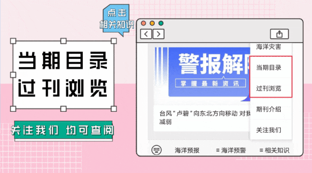
读者也可以通过公众号菜单栏
“相关知识”板块进入
《当期目录》和《过刊浏览》
查阅详细期刊内容


更多滨海旅游海况预报 尽在中国海洋预报


点击下方图片
进入“中国海洋预报”微信小程序

点击下方图片
进入“全球海啸预警”微信小程序

长按下方图片,识别二维码
关注“国家海洋环境预报中心”公众号